
(NEW YORK) — Millions of people across the country are buckling up for wild temperature swings of up to 30 degrees this week.
The roller-coaster-like dips and highs in temperatures across most of the nation will come amid a late-season snowstorm in Denver and Rocky Mountains. An Illinois dust storm threat could reduce visibility to less than a quarter of a mile.
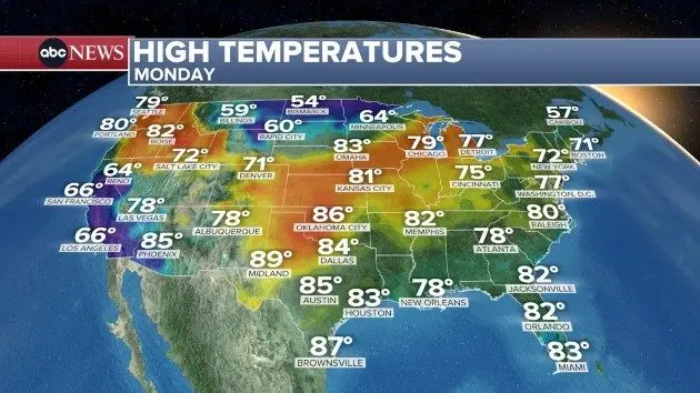
Whiplash temperature swings
On Monday, temperatures will be above average across much of the Midwest and Northwest, and below average in California and southwest Arizona.
Temperatures are expected to climb to 80 on Monday from Chicago to Kansas City — making it 10 to 15 degrees above average for this time of year.
Oklahoma City and Dallas are forecast to be in the mid-80s on Monday. Meanwhile, California’s Bay Area and Los Angeles are expected to be in the mid-60s on Monday — 5 to 10 degrees below average for the first week of May.
But on Tuesday, temperatures are expected to dramatically drop across parts of the Midwest, including Chicago, which is forecast to see a 20-degree decline, and Denver with a 30-degree decline.
Severe storms are also possible on Tuesday from Dallas to Jonesboro, Arkansas, with the main threats expected to be large hail, damaging wind and possible isolated tornadoes. On Wednesday, severe weather moves across east Texas and into central Alabama, bringing damaging wind, large hail, possible tornadoes and the risk of flash flooding.
New York City, Washington, D.C., and Raleigh, North Carolina, are expected to top 80 degrees on Tuesday — which is 5 to 15 degrees above average for this time of the year.
On Wednesday, a rush of cold air is expected to bring widespread below-average temperatures across the Midwest and Great Lakes.
By Friday, cooler-than-normal temperatures spread across the East and South, while the West goes above average with highs near 100 for Phoenix and Las Vegas, while only reaching the 60s in New York City and Washington, D.C., and the 50s in Boston.
Snow in Colorado
The Colorado Rocky Mountains have received a record-low snowpack this winter. But a late-season snowstorm expected in the area beginning Monday and running through Wednesday could bring a foot to 2 feet of much-needed snow to the Rockies.
Winter storm alerts are in place for parts of Colorado and Wyoming through Wednesday. The heaviest snow is forecast to fall on Tuesday and Wednesday.
The Denver metro area could see 3 to 9 inches of snow on Tuesday and Wednesday.
The pending storm is already making an impact on America’s favorite summer pastime — baseball. The start time of Monday’s game in Denver between the New York Mets and the Colorado Rockies has been moved up three hours to 3:40 p.m. MT due to potential snow.
Blowing dust in Illinois
A rare blowing dust advisory has been issued in Illinois, including the Chicago area. Blowing dust was already an issue in Central Illinois on Sunday.
Visibility of less than a quarter mile is possible on Monday in some agricultural areas of the region.
It’s only the second time in history that the National Weather Service (NWS) office based in Chicago has issued a blowing dust advisory. The first advisory was on May 16, 2025, when a large dust storm caused visibility to drop to near zero and wind gusts rose to 60 mph in Chicago and across the area, according to the NWS.
Copyright © 2026, ABC Audio. All rights reserved.